
Maps and Genealogy
While researching my ancestors, I often find it helpful to place them on a map. Mapping can give context to our ancestors’ lives, lifestyles, and occupations. Mapping also can be useful to flesh out a family story or document a family’s migration. In any event, using online map resources to pinpoint historic locations can sometimes be tricky. Place names often change over time, whether it is the name of a town or a street. Address numbers also change when modern city planning techniques are introduced. For this week’s prompt, I will describe using online historic maps, and other resources, to identify locations where my great-grandfather lived in Indianapolis, IN.
Mapping Example One
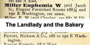
My great-grandfather, David L. Osborne 1848-1942, lived at 188 ½ East Washington Street in Indianapolis in 1881 and 1890, and possibly at other times. [1, 2] This address, and the landlady, play an important role in the story of my great-grandfather, his wives and his children. I wrote a post about it a few years ago, “The Marriage of David and Jennie Osborne.” [3] For those not familiar with Indianapolis, Washington Street is the dividing line for north and south street addresses, “E(ast) Washington” being east of the east-west dividing line, Meridian Street. The address number “188” (today) indicates a location within two blocks of Meridian Street. This places it near Delaware Street to the east, and the even number indicates it is on the north side of the street. The “½” traditionally suggests a second-story residence. Using Google Maps (maps.google.com), search for this address and you will discover it does not exist. Instead, a pin will drop at the corner of Washington and Delaware Streets. This location is probably close, but not exact. It’s now time to turn to the historic Sanborn Fire Insurance Maps on the IUPUI website. See the side-box for resource and link details.
Resources Used
- Indianapolis Sanborn Map and Baist Atlas Collection in the Indiana University-Purdue University Indianapolis University Library Digital Collections
- Digital images of historic Indianapolis city directories at Internet Archive
- Digitized Indianapolis ordinance books at Google Books
Although my example is for Indianapolis, similar resources are available for most U.S. cities.
Sanborn Fire Insurance Maps
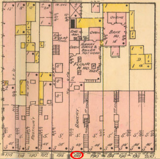
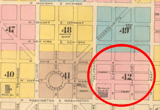
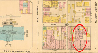
I used the 1887 Sanborn map since it is the closest year available for my 1890 example. From the index map I determined I needed to access map #41 which includes East Washington and Delaware Streets. However, upon accessing map #41, I soon realized that in 1887 the address numbering scheme was 50 per block, unlike today which is 100. That means I need the next map east, map #42. [4] The lesson here is numbering schemes change as modern planning techniques are adopted. On map #42 the address 188 East Washington is about 230 feet west of North New Jersey Street and it is a bakery with rented rooms on the second floor. More information about the symbols used can be found on the index maps’ key.
Google Maps
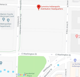
To discover the modern address for 188 East Washington Street, I turned to Google Maps. I know the address is between Alabama and New Jersey Streets, which is now the 300 block of East Washington. Looking at this general location on Google Maps reveals the entire block is now the Cummins Corporation. [5] No more bakery, no more rented rooms.
Mapping Example Two
As a second example I will locate the Indianapolis address my great-grandfather lived at in 1892, 17 Omer Street. I found my great-grandfather at this address in the 1892 R.L. Polk Directory. [6] Looking on Google Maps, I quickly realized this street name no longer exists in Indianapolis. There are two methods I could use to discover the new name for Omer Street. One uses the city directories the other uses city ordinances for street naming.
Street Name Change
I skipped ahead a few years in the city directory to the 1896 R.L. Polk Indianapolis City Directory and consulted the section “New Streets and Street Changes.” [7] Sure enough, under Omer is the note, “See E. Eleventh.” If the directories you are using do not have a section with street name changes, an alternative is to look for city ordinances. In this case I use Google Books (books.google.com) and search for “city ordinances Indianapolis.” For my example, I chose the resulting title that was published in 1904. [8] It’s a free e-book and I have added it to my virtual bookshelf for future reference. Using the Search function I searched for “Omer” and got 2 results, not counting the Index. On page 1024 I found,
3488. Eleventh. Omer street, now extending east from Brookside avenue to its eastern terminus, being on the East Eleventh street numbering-line, hereafter shall be known as East Eleventh street.
This information about the street name change confirms what is found in the city directory. But what is the modern house number?
Street Address
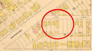
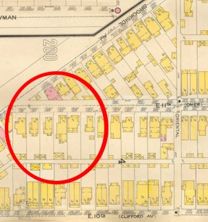
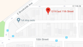
I returned to the 1887 Sanford Fire Map, as in the previous example, and selected the appropriate map for Brookside and 10th Street. Map 64 in the 1887 collection shows Omer one street north of East 10th Street, and 17 Omer as a vacant lot. But, I can count from the corner that 17 Omer is the 5th lot east of Brookside. Now consult Google Maps for the Brookside and East 11th intersection and count over 5 lots to discover the modern address is 1319 E. 11th Street. [10] When I visited this location 5 years ago it was again a vacant lot, but now there is a new house! I am happy to say it is in a style consistent with the age of the neighborhood.
Conclusion
Several years ago I wrote a post about finding the 23 addresses in Indianapolis where my great-grandfather lived between 1876 and 1942, “David L. Osborne, His Indianapolis Homes.” [11] All of the sites used for this article are free, but some do require an account to access the materials. Consult my list for more online Indiana map resources. The final three on the list have historic maps from all over the world. For next week’s prompt, Landed, I will discuss using Bureau of Land Management (BLM) records to map where my ancestors lived.
Online Map Resources
- Historic Indiana Plat Books
https://www.ulib.iupui.edu/digitalcollections/indianaplat - Historic Indiana Maps
https://ulib.iupui.edu/digitalcollections/HIM - Historic Indiana Atlases
https://www.ulib.iupui.edu/digitalcollections/HistAtlas
- Indiana Historic Maps
http://webapp1.dlib.indiana.edu/images/splash.htm?scope=images/VAC3073 - Library of Congress Maps
https://www.loc.gov/maps/ - Old Maps Online
https://www.oldmapsonline.org/ - David Rumsey Map Collection https://www.davidrumsey.com/view/luna
EPILOGUE
From the Indiana State Library:
Parrott-Nickum Cracker Company
One of the predecessors of the Parrott & Taggart Cracker Company began sometime around the Civil War when Horace Parrott and John Nickum formed the Nickum-Parrott bakery. After some time Nickum left the business. However, he soon rejoined Parrott with the names of the business reversed as Parrott-Nickum Bakery.
By 1883 Parrott-Nickum & Co. occupied three floors for sales, manufacturing, and storage at 190-192 East Washington Street. In 1883 the businesses of Parrott-Nickum and that of Taggart Brothers consolidated to form a branch of the U. S. Baking Company called Parrot & Taggart Cracker Company. It was located at 93-99 Pennsylvania Street and was the largest business of its type in Indiana.
Parrot and Taggart Cracker Company manufactured all sorts of crackers, breads, and fancy biscuits. They employed over 150 people and used 30,000 barrels of flour a month. Manufacturing of crackers, snaps, and biscuits was done by time-saving machines that were sustained by one 30-horsepower engine and boiler. Every ten hours approximately 100 barrels of flour were used. The business extended throughout Indiana, and into Illinois, Kentucky, and Ohio. They had annual sales of $150,000.
SOURCES:
- Profile of David Louis Osborne, ‘Osborn‘ tree, Ancestry.com; https://www.ancestry.com/family-tree/person/tree/13493206/person/-60124040/facts
- Entry for David L. Osborn, R. L. Polk and Co.’s Indianapolis City Directory for 1890 (Indianapolis: R. L. Polk & Co.), page: 600, in “Indianapolis City Directory Collection” database of The Indianapolis Public Library, digital image, Internet Archive; https://archive.org/stream/polksindianapoli1890unse#page/600/mode/1up : accessed 10 June 2017
- Blog post, Family Finds: The Marriage of David and Jennie Osborne;; https://barblafara.com/the-marriage-of-david-and-jennie-osborne/
- Insurance Maps of Indianapolis, Indiana (New York: Sanborn Map and Publishing Co., 1887), vol. 2, map 42; digital image, IUPUI University Library; http://indiamond6.ulib.iupui.edu/cdm/singleitem/collection/SanbornJP2/id/361/rec/7 : accessed 12 June 2017
- Website, Google Maps; https://www.google.com/maps/place/300+Washington+St,+Indianapolis,+IN+46204/@39.7673234,-86.1525384,318m/ : accessed 12 February 2022
- Entry for David L. Osborne, R. L. Polk and Co.’s Indianapolis City Directory for 1892 (Indianapolis: R. L. Polk & Co.), 633, in “Indianapolis City Directory Collection” database of The Indianapolis Public Library, digital image, Internet Archive; https://archive.org/stream/polksindianapoli1892unse#page/633/mode/1up : accessed 14 June 2017
- Entry for Omer, R. L. Polk and Co.’s Indianapolis City Directory for 1898 (Indianapolis: R. L. Polk & Co.), page 90, in “Indianapolis City Directory Collection” database of The Indianapolis Public Library, digital image, Internet Archive; https://archive.org/stream/polksindianapoli1898unse#page/90/mode/1up : accessed 14 December 2017
- The General Ordinances of the City of Indianapolis: Containing, Also Acts of the Indiana General Assembly, So Far as They Control Said City, to which is Prefixed a Chronological Roster of Officers from 1832 to 1904, and Rules Governing the Common Council, Collated and Annotated by Edgar A. Brown and William W. Thornton, page 1024, image, Google Play Books; https://play.google.com/books/reader?id=8vUNAQAAMAAJ : accessed 14 June 2017
- Insurance Maps of Indianapolis, Indiana (New York: Sanborn Map and Publishing Co., 1887), vol. 2, map 64; digital image, IUPUI University Library; http://indiamond6.ulib.iupui.edu/cdm/singleitem/collection/SanbornJP2/id/383/rec/29 : accessed 14 June 2017
- Website, Google Maps; https://www.google.com/maps/place/1319+E+11th+St,+Indianapolis,+IN+46202/@39.7821307,-86.1365533,18.18z : accessed 12 February 2022
- Blog post, Family Finds: David L. Osborne, His Indianapolis Homes; https://barblafara.com/indianapolis-addresses-for-david-l-osborne/




0 Comments