52 Ancestors,
in 52 Weeks
Week 7:
Landed
Land Maps for Genealogy
While researching my ancestors, I often find it helpful to place them on a map. Land records can be particularly helpful for locating where my ancestors lived. Colonial America used a system called “metes and bounds” which relied heavily on landmarks, like trees and creeks, and accepted boundaries for neighboring land. However, beginning in 1785, the United States government’s surveyors adopted the rectangular method of laying out property. [1] As a result, most lands west of the original 13 colonies are platted in a method using Ranges, Townships and Sections to identify property boundaries. For this week’s prompt, I will describe using land records to locate where my 3rd great-grandfather lived in Ohio more than 180 years ago.
Samuel Gilbert, 1812-1895
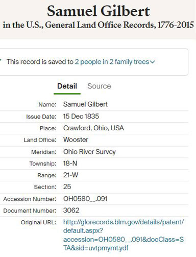
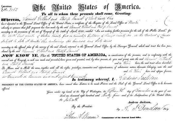
I previously wrote about Samuel Gilbert, one of my maternal 3rd great-grandfathers, for last year’s Week 12 prompt “Loss.” [2, 3] He is also one of my brick walls. Samuel was born in Pennsylvania, but lived his adult life in Ohio. The earliest record I have for him is a land record from 1835. [4] I used this record to find the location of Samuel’s farm land and to discover who his neighbors were. By identifying Samuel’s neighbors I am hoping to discover information that will help break his brick wall.
Nineteenth Century Land Records
Here is the land record provided by Ancestry.com for Samuel Gilbert. The information provided does let me find the location on a map, if you know how to translate the data. In this case, Ancestry provides a link to the Bureau of Land Management (BLM) record. However, even if you do not have a record like this one, you should be able to find your ancestors’ land record on the BLM site with just basic information.
Bureau of Land Management
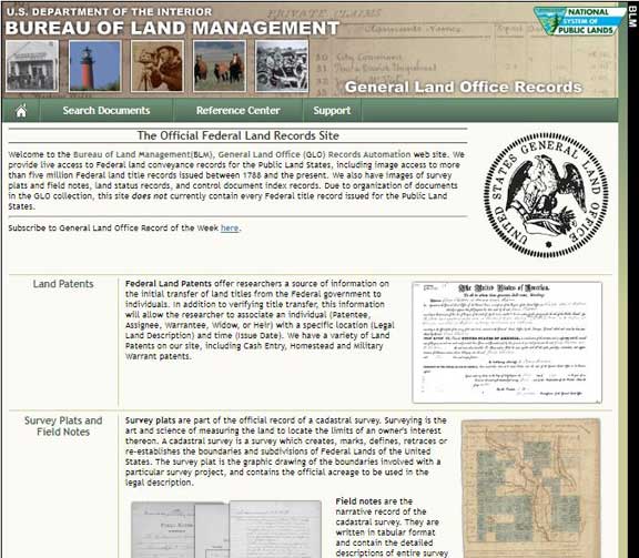
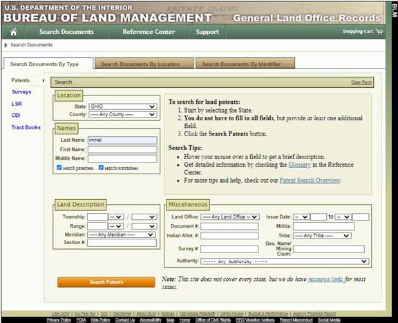
Access the main page for land records of the BLM at: https://glorecords.blm.gov/ and select the link called “Land Patents.” [5] This takes you to a page where you can search for your ancestor using their name. However, the more information you have about their land ownership, such as state and county, will help narrow your search results. Additionally, if you have any portion of their land description (range, township, doc. number, etc.) your search results will be much improved.
BLM Land Map Example
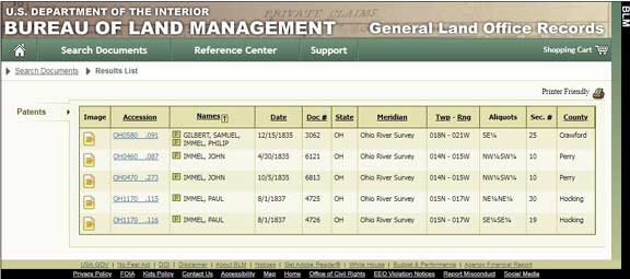
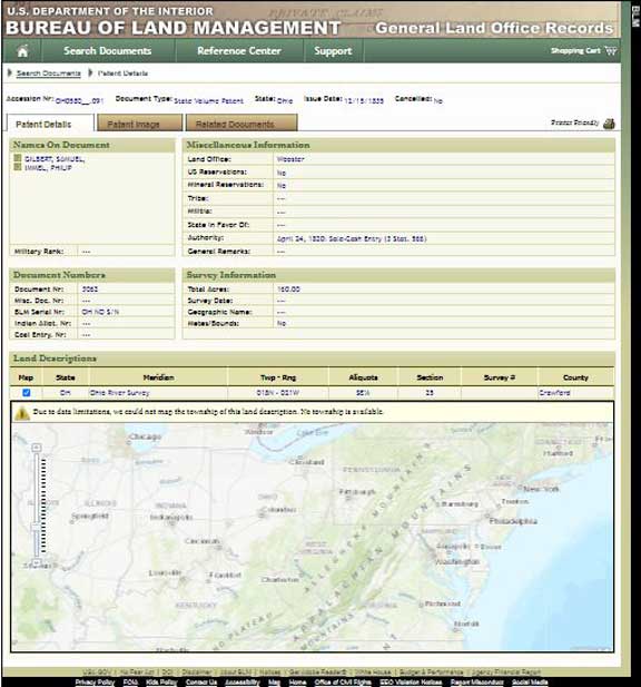
For my ancestor, I performed a search using the name of his property co-owner (Immel) since his surname is more unusual. And I selected the state of Ohio as the location. The search results are just five records and the first one is for my ancestor and his partner. Click on the “Accession” number and you will go to a page with more details about the land patent. Make note of the information provided just above the map of the United States. The heading “Twp-Rng” stands for Township and Range, these numbers, along with Aliquots and Section, will be helpful to finding your ancestors’ property on a map.
Finding Range and Township
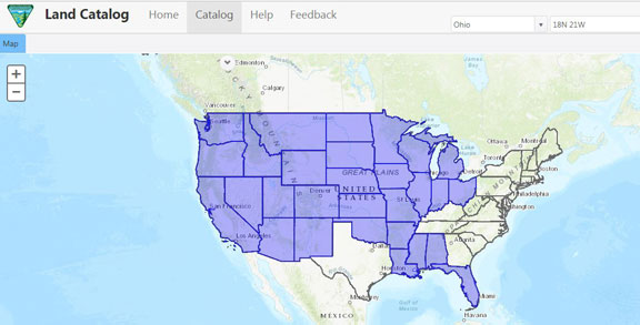
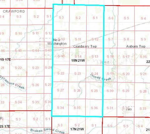
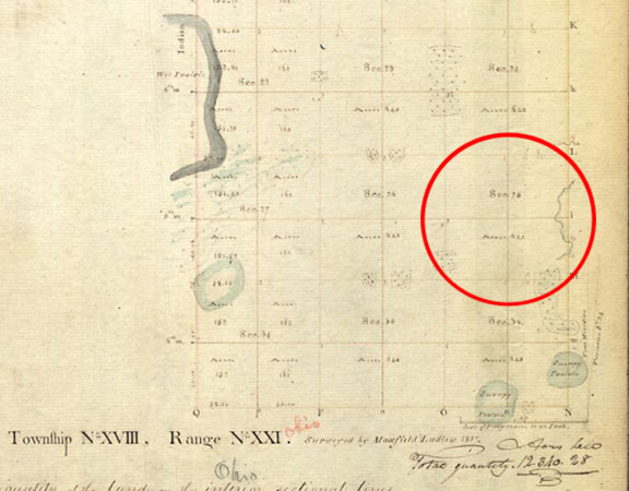
The patent details page on the BLM website has a map. Use the checkbox next to the land description and the map should zero in on the property. However, from my experience, this map feature often does not work. If that is the case for you, there is another option. Open the BLM home page in a new tab, then scroll down the home page and use the link “Land Catalog.” [6] https://glorecords.blm.gov/LandCatalog/Catalog This opens a page with a map of the United States with areas shaded in blue. These blue shaded areas cover the land included in the BLM records. At the top right on the screen fill in your information for state, township, range, and section from the land record results. For my example it’s Ohio, 18N 21W, and 25. This causes the map to zoom in to the entered location. But, you still need to use the “Aliquots” from the record to further locate your ancestors’ property. For my example, my ancestor co-owned the 160 acres of land in the “SE 1/4” of section 25.
Modern Map Location
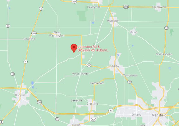
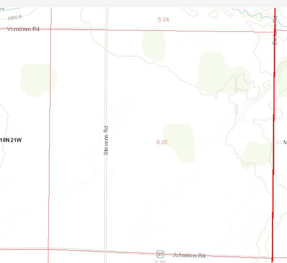
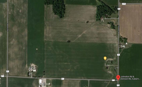
Looking at the BLM land map for my example, you can see the SE ¼ is the northwest corner of the intersection of Johnston and Dickson Roads. Using Google Maps, or some other mapping program, I can enter this intersection information and find a modern address and/or geo-location for my ancestors’ property. [7] Using the satellite layer of the map, I can see there is still a farm at this location. Nice. I’ve dropped a pin and recorded the latitude and longitude for future reference.
I have included a broader area map at right. My ancestors’ land was northeast of Bucyrus, in Crawford County, OH.
Conclusion
I have found the Bureau of Land Management site useful for mapping the land owned by my 19th century ancestors. Although this example is for a regular land purchase, the BLM database can be used to look up military service bounty land, too. And, the Land Catalog can be used to look for any land for which you have township, range and section. Lastly, I encourage you to investigate what other information can be found on the BLM website. For example, not only is Samuel Gilbert a brick wall for me, so is his wife, my 3rd great grandmother, Sarah Smith. Using the BLM records, I discovered five men named Smith living within the same township as the Gilbert’s. I am considering them as leads for finding Sarah’s family. See my bonus tip below.
Resources Used
- Bureau of Land Management land records at the US Department of the Interior date back to 1785.
- Land Catalog maintained by the BLM allows searching or browsing by Township, Range and Section.
- Ohio Land and Property Resources at Family Search.
EPILOGUE
Beyond the Map
The BLM record provides more than just location if you look further. From the Patent Details page there are clickable tabs for the Patent Image and Related Documents. The Patent Image is a digitized version of your ancestors land patent. The Related Documents tab includes the accession numbers and names of other property owners in the same section. If you want to find a larger number of immediate neighbors, return to the Search page and enter the township and range under Land Description for a broader search. Alternatively, you could enter specific nearby sections to narrow your search results. Using the links on the left side of the Related Documents tab will also let you access the original survey, if it exists. The other links on the left will not typically yield results for your ancestors unless they were involved in mining or public lands.
SOURCES:
- Online document, Bureau of Land Management, “A History of the Rectangular Survey System,” https://www.blm.gov/sites/blm.gov/files/histrect.pdf; accessed 19 February 2022
- Profile of Samuel Gilbert, ‘Osborn‘ tree, Ancestry.com; https://www.ancestry.com/family-tree/person/tree/13493206/person/12164041102/facts
- Blog post, Family Finds: Loss; https://barblafara.com/loss/
- Land patent entry for Samuel Gilbert, Certificate# 3062; Bureau of Land Management, General Land Office Records; Washington D.C., USA; Federal Land Patents, State Volumes; Ohio, Crawford County, image 468 of 2077; accessed online at Ancestry.com: https://www.ancestry.com/discoveryui-content/view/1615576:1246?ssrc=pt&tid=13493206&pid=12164041102
- Website, BLM GLO Records;
https://glorecords.blm.gov/default.aspx : accessed 19 February 2022 - Website, BLM Land Catalog;
https://glorecords.blm.gov/LandCatalog/Catalog : accessed 19 February 2022 - Website, Google Maps, Johnston Rd & Dickson Rd, OH 44887; https://www.google.com/maps/place/Johnston+Rd+Dickson+Rd,+OH+44887/@40.9170563,-82.8008068,17z: accessed 20 February 2022
1 Comment
Submit a Comment



Thank you for the detailed information on using the Bureau of Land Management site.